Cyclades Sailing |
||||||||||
|
||||||||||

|
||||||||||
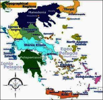
A group of islands pertaining to the Aegaen Sea, southeast oif Greece is named The Cyclades. In ancient Greece all those islands once belonged to The Cyclades: Andros, Delos, Milos, Naxos, Paros, Kea, Kythnos, Mykonos, Serifos, Sifnos, Syros and Tinos. Delos was sourrounded and then meant to be sacred. Beside all the islands mentioned, today also are included: Ios, Amorgos, Thira, Anafi and 200 other small islands who once originated to the Sporades. The Cyclades population is roughly 90.000. This group of islands became part of Greek in 1829. |
||||||||||
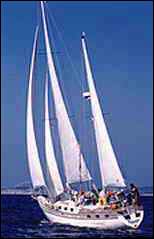
"Anahita II" |
||||||||||

|
||||||||||
This was "our" crew |
||||||||||
|
||||||||||
|
||||||||||
LAVRION > KEA |
||||||||||
Kea - in a distance of only 20 km to Kap Sounion, is the westernmost Island of the large Cyclades with 1.600 inhabitants (130 km2), capital city is Kea. Various ferry-connections with Lavrion. Because of population drain cattle breeding and terraced fieldwork have almost decreased. In early history the population on the island were Dryopean from Euböa and later among others also the Ionian. Joining Athens, Kea also took part in the battle of Salamis (480 B.C.). Since 1207, during the Middle Ages, the island came under the rule of Venecian Dukes, then since 1579 belonged to the Ottomans and after the Greek war of liberation, finally came to Greece. |
||||||||||
Kea > KYTHNOS |
||||||||||
Kythnos - an island strongly developed to karst and rocks, 1.600 inhabitants (99 km2), capital city is Kythnos. Various ferry-connections. Dryopian coming from Euböa, immigrated apr. 2000 B.C. but later were driven out again by the Ionian. 1207 - 1537 the island was Venecian, then Osmanian until annexation to Greece in 1830. In ancient times iron ore mining was important. |
||||||||||
|
||||||||||
Kythnos > SYROS |
||||||||||
Syros - The Cyclades administration- fishing- and commercial trading centre, and in the Aegaen Sea also important shipping traffic junction. Various ferry-connections. Inhabitants 20.000, living on mountainous 86 km2. Ermoupoli is the capital city and the Cyclades prefects headquarter as well as of a Roman Catholic bischop and an orthodox archbishop. Todays poluation are 40% Catholic and 60% orthodox. Agriculture (horticulture and milk products), shipyard- and textile industrie, little tourism yet. The island belonged to the dukedom of Naxos in 1207 and was influenced Catholic since. |
||||||||||
|
||||||||||
Syros > PAROS |
||||||||||
Paros - Connections with Athens by air and ferries. 8.000 inhabitants in an area of 186 km2, capital city is Paros (Parikia). The island attracts various tourists as well as backpackers. Its interior still is very unspoiled, and famous since the ancient world for its marble, what still is modestly broken in our days. Otherwise cultivable areas for wine, barley, fruit and vegetables. The island was populated even before the third millennium and became famous for its naval power during the first millennium by the Ionians. |
 |
|||||||||
Later in the 6th and 5th cent. B.C. the famous Parish school of sculpture was founded. |
||||||||||
|
||||||||||
Paros > NAXOS (RINA) |
||||||||||
Naxos - connections to Athens by air or various ferries. It is the largest and most charming island in the Cyclades. Inhabitants 14.000 in an area of 448 km2, capital city is Naxos. Terraced agriculture (wine, citrus fruits, potatoes, vegetables, grain and fruit), beside products of marble and sandpaper as well as sea salt extraction since the ancient world. Place of cultural intererest for Dionysos - famous school of sculpture - diocesan town in 1083 - joining the Greek kingdom in 1830. There would be much more to tell about this islands interesting historical background ... But our stay on Naxos only included the night of a full moon at sea, alongside the isolated sandy beach of Rina - even with its own terribly romantic grotto, navigable only by a dingi. |
||||||||||
|
||||||||||
Naxos > DONOUSSA |
||||||||||
Donoussa - part of the small Cyclades, this island is situated between Naxos and Amorgos, and often is exposed to the Meltemi winds because its situation most to the east. Like frequently in the Cyclades, the land form is barren but here are magnificant overviews and various nice sandy beaches. Most of the 120 inhabitants live in Agios Stavros, also the ferries stop there. Only there one can find accommodations. Among three other little villages is the most beautiful Kalotaritissa in the north with its 20 inhabitants. The most productive water source of the Cyclades is in Mersini (15 inhabitants), visit this place and you seem to be carried off into little paradise. On this smal island only few cars will be seen and accommodations are exceptional. |
||||||||||
Donoussa |
||||||||||

|
||||||||||
|
||||||||||
Donoussa > PATMOS |
||||||||||
|
 |
|||||||||
Patmos - from Athens various ferry-connections (Skala), during summer also with hydrofoils, situated south of Samos. Because this islands vulcanic origin it is bleak, hilly and with deeply fissured rocks (2.800 inhabitants living on 34 km⊃2;, capital is Patmos). It is accepted as a holy place by the Orthodox as well as by the Catholic and Protestant world of faith. Since the Middle Ages it is known for the island of St. John the evangelist, who supposingly wrote the Apokalypsis while living here in exile in 95 AD. |
||||||||||
|
||||||||||
Patmos |
||||||||||

Blick (view) v. Johanneskloster - Skála |
||||||||||
|
||||||||||
Patmos > ARKI |
||||||||||
Arki - the island of 37 inhabitants, not counting the goats! Sailing into the little fishing village, it feels like a totally different planet to the buzzing metropolis of Samos, just 25 miles north. Some of the older folks here have scarcely left the island in decades, and everyone is someone’s cousin. Among three taverns, the main "cool" spot on Arki is Manoli’s taverna. A little shaded courtyard, with speakers arranged randomly in the trees - it’s a music and flower-filled oasis on this rocky little island. The owner is most definitely "Mr Cool": Manoli has lived for years in Athens and Germany, but chose to return to his home island for the quiet life. Happily for us, he also brought back with him a great love and collection of music: it's not unusual for a spontaneous evening of dancing to break out here! |
||||||||||
Arki |
||||||||||

|
||||||||||
|
||||||||||
|
 |
|||||||||
Arki > SAMOS |
||||||||||
Samos - connections by air from Athens and Thessaloniki, airport at a distance of 3 km from Pythagoreio. Various ferry-connections. 33.000 inhabitants on 476 km2, capital is Samos. Beside the famous sweet wine 'Samos' (white muskat grapes) various other attractions. The island is green, wooded, hilly, rich of water supplies and a popular destination for vacations on the beach as well as for hiking. Even though repeating various forest-fires, its tree population always can be regenerated. Separated from the Turkish coast only by a 1.900 meter strait (peninsula Dilek). Agriculture (wine-growing, olives, oranges, figs, tobacco, grain, fruit, vegetables and others), shipbuilding, fishing, and since two decades also tourism. The island came to its highest political and economic power during the second half of 6th century BC, in the reign of tyran Polykrates (ballad of Schiller !), being a despot with feelings for philosophy, but later was crucified around 522 BC. Home of the mathematician and philosopher Pythagoras (about 570 until 496/497 BC), and the astronomer Aristarch (about 310 until 230 BC), with his anticipation about the conception of the world, trying to determine the earth's distance to the moon and the sun. More about this islands interesting periods of history to be found on the Internet. 1913 integration into the kingdom of Greece. |
||||||||||
|
||||||||||
|
||||||||||
|
||||||||||


